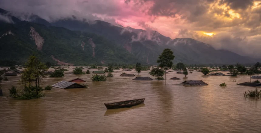
The hills of Arunachal Pradesh came down in a roar this week — flash floods and landslides washed away a highway bridge, cut off six districts and left people missing. And as that water rushes downhill, the plains of Assam are now bracing for the second act.
It’s a grimly familiar story in Northeast India. But why does this same corner of the country drown almost every single monsoon? The answer is a fascinating — and frightening — mix of geography, geology and the heaviest rain on Earth. Here’s what happened, and the science of why it keeps happening.
⚡ Quick Take
- What happened: Flash floods & landslides hit Arunachal Pradesh on 24 June 2026 — 6 districts cut off, a bridge washed away, 1 dead and 4 missing.
- Next in line: Assam is on high alert as swollen rivers push downstream; Dhemaji alone has 20,000+ people affected.
- The big question: Why every year? Record rainfall + a silt-choked Brahmaputra + fragile young hills = a near-annual flood machine.
What Actually Happened
On the morning of 24 June 2026, incessant rain triggered a flash flood at the NEEPCO Colony in Poosa, in Arunachal Pradesh’s Keyi Panyor district. According to The Federal, the deluge damaged around 18 homes, washed out a highway bridge and set off landslides across the hills. A 35-year-old woman’s body was recovered, four people were left missing, and 17 were injured.
The bigger problem was isolation. Six districts — Keyi Panyor, Kra Daadi, Kurung Kumey, Lower Subansiri, Kamle and Upper Subansiri — were cut off from the rest of the state as landslides buried key roads, including a stretch of National Highway-13. The Indian Air Force flew in to airlift disaster-response teams, while the Border Roads Organisation and excavators began clearing the debris. Chief Minister Pema Khandu assured affected families of full government support.
Why Assam Is Bracing Next
Here’s the part that makes Northeast floods so relentless: the rain falls on the hills, but the flood lands on the plains. The water that hammered Arunachal doesn’t just stay there — it pours down through rivers like the Subansiri, Ranganadi and Jiyadhol straight into low-lying Assam.
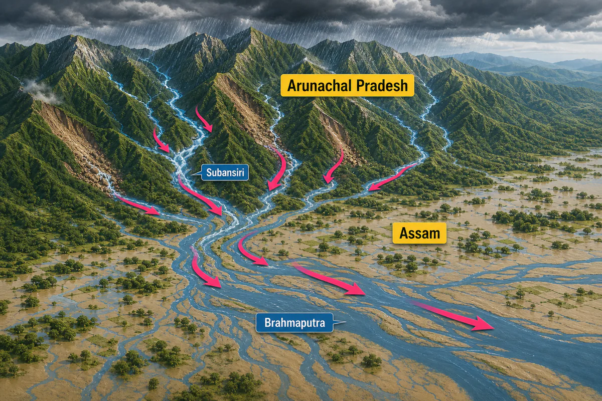
It’s already happening. Per the Assam Tribune, Dhemaji is the worst-hit district with more than 20,000 people affected by the swelling Jiyadhol, with Majuli, Lakhimpur, Biswanath, Golaghat, Dibrugarh and South Salmara-Mankachar also reeling. In Lakhimpur, the Ranganadi rose sharply after water was released from an upstream hydroelectric project — a vivid example of how human decisions upstream can deepen a natural flood downstream. The SDRF and NDRF are deployed, relief camps are open, and Chief Minister Himanta Biswa Sarma has put all agencies on maximum alert.
Why Does the Northeast Flood Almost Every Year?
This is the question worth understanding — because the Northeast isn’t just unlucky. It sits at the meeting point of several extreme forces:
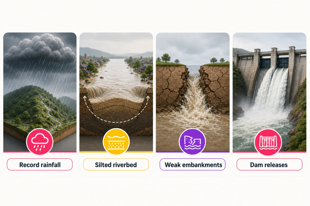
- The heaviest rain on the planet. Meghalaya’s Mawsynram and Cherrapunji are among the wettest places on Earth, and the wider region soaks up enormous monsoon downpours in June and July. There’s simply more water here than almost anywhere else.
- A river that’s rising from the inside. The mighty Brahmaputra carries one of the world’s largest sediment loads, scoured from the young, crumbling Himalayas. All that silt settles on the riverbed, slowly lifting it higher — so the same volume of water spills over far more easily. It’s like a bathtub that keeps getting shallower.
- Young, fragile mountains. The Eastern Himalayas are steep, geologically new and prone to landslides. Rain doesn’t soak in slowly — it sheets off the slopes in minutes, turning streams into flash floods and roads into rubble, exactly as Arunachal just saw.
- An earthquake zone. The Northeast is one of India’s most seismically active regions. Quakes loosen hillsides and, historically, have even raised riverbeds — the massive 1950 Assam earthquake is widely blamed for worsening the Brahmaputra’s flooding for years afterward.
- Ageing embankments & upstream dams. Many of Assam’s earthen embankments date back decades and breach under pressure, while sudden releases from upstream dams — like the Ranganadi this week — can send a wall of water downstream with little warning.
Stack all of that together and you get a region almost engineered by nature to flood — then amplified by human choices. Climate change is now adding shorter, fiercer rain bursts on top, which makes the flash-flood risk worse still.
🤯 Did you know? Majuli, sitting in the middle of the Brahmaputra in Assam, is the world’s largest river island — and it’s been shrinking for decades as relentless flood erosion eats its banks away. The same river that created it is slowly washing it back into the water.
The Human & Wildlife Cost
Behind the maps and statistics are families in relief camps, washed-out farmland, and drowned livestock. The Northeast’s floods routinely swamp tea gardens and paddy fields, and in bad years they breach the famous Kaziranga National Park, where rhinos and deer are forced onto highlands and roads. This year, Assam ministers fanned out across the affected districts on 25 June and signalled a push toward long-term fixes — stronger embankments and “scientific river management” — rather than only emergency relief.
Frequently Asked Questions
What is happening with the Northeast India floods in June 2026?
Heavy rain triggered flash floods and landslides in Arunachal Pradesh on 24 June 2026, cutting off six districts, washing away a highway bridge and leaving one person dead and four missing. The water is now flowing downstream into Assam, where Dhemaji and several other districts are flooding and the state is on high alert.
Why does Northeast India flood almost every year?
The region gets some of the heaviest monsoon rainfall on Earth, while the Brahmaputra carries a huge sediment load that raises its riverbed and makes it overflow easily. Add steep, landslide-prone young Himalayas, high earthquake activity, ageing embankments and sudden upstream dam releases, and the area floods almost every monsoon.
Which districts are worst affected by the 2026 floods?
In Arunachal Pradesh, Keyi Panyor, Kra Daadi, Kurung Kumey, Lower Subansiri, Kamle and Upper Subansiri were cut off. In Assam, Dhemaji is worst-hit with over 20,000 people affected, along with Majuli, Lakhimpur, Biswanath, Golaghat, Dibrugarh and South Salmara-Mankachar.
How does rain in Arunachal cause floods in Assam?
Arunachal Pradesh is mountainous, so its heavy rain runs off fast into rivers like the Subansiri, Ranganadi and Jiyadhol. Those rivers flow down into the low, flat Assam plains and feed the Brahmaputra, so a downpour in the hills becomes a flood on the plains a day or two later.
Can dam water releases make the flooding worse?
Yes. When an upstream hydroelectric reservoir releases water during heavy rain, it can raise downstream river levels sharply and with little warning. In Lakhimpur this week, the Ranganadi rose quickly after a release from an upstream project, adding to the natural flood.
The Bottom Line
The Northeast’s floods aren’t a one-off disaster — they’re the predictable collision of the world’s heaviest rains, a sediment-choked super-river, and some of the youngest, shakiest mountains on Earth. Arunachal’s hills take the first hit; Assam’s plains take the long, slow second one.
What changes the story isn’t the rain — that’s a given. It’s whether the embankments hold, the dam releases are managed, and the warnings reach people in time. Until then, every monsoon, the same rivers will keep telling the region the same hard truth.
Sources: The Federal (Arunachal Pradesh floods) and the Assam Tribune (Assam flood response). Casualty and impact figures are as reported and were still being updated.